Funded by the Hurricane Sandy Coastal Resiliency Competitive Grant Program through the National Fish and Wildlife Foundation
Overview
Problem and Background
Hurricane Sandy Coastal Resiliency Grant Program
Final Report
Wood-Pawcatuck Watershed Flood Resiliency Management Plan
Appendix A – Baseline Assessment
Appendix B – Steering Committee Meetings
Appendix C – Watershed Plan Survey
Appendix D – Community Meetings
Appendix E – Subwatershed Maps
Appendix F – Town Summary Sheets
Appendix G – Dams, Bridges, Culverts Assessment
Appendix H – Geomorphic Assessment
Appendix I – River Corridor Plan
Appendix J – River Corridor Restoration Concept Sheets
Appendix K – Land Use Policy and Regulations
Appendix L – Wetlands Assessment
Appendix M – Green Infrastructure
October Community Meetings Materials
Community Meeting Slideshow
Subbasin Maps
Overview
In 2014 WPWA was awarded a $720,000 grant to develop a watershed wide management plan for flood resiliency. This project addresses the problems faced by cities and towns in the Wood-Pawcatuck Watershed caused by extreme weather events. The Hurricane Sandy Coastal Resiliency Competitive Grant Program supports projects, such as this, that reduce communities’ vulnerability to the growing risks from coastal storms, sea level rise, flooding, erosion and associated threats through strengthening natural ecosystems that also benefit fish and wildlife. The program, funded by the Hurricane Sandy disaster relief appropriation through the Department of the Interior (DOI), was administered by National Fish & Wildlife Foundation. The three year project was completed in mid 2017.
The Wood-Pawcatuck Watershed Flood Resiliency Management Plan was researched and drafted by the engineering firm of Fuss and O’Neil, who had previously designed fish passage projects on the Pawcatuck River. The project involved assessing the existing conditions and an evaluation of what can be done to avoid or mitigate future impacts from catastrophic storms. Regular meetings with all the watershed communities and interested stakeholders were held before, during, and after the plan was drafted. This project produced a management plan which includes a list of actions and tools that cities and towns now use to protect themselves from future weather related events. The RI Department of Environmental Management worked closely with WPWA to ensure that the management plan also meets the State’s needs for it’s EPA required watershed management plan. The goal of the project, creating a guiding document that RIDEM and local communities can adopt and begin using was successfully achieved in 2017.
Problem and Background
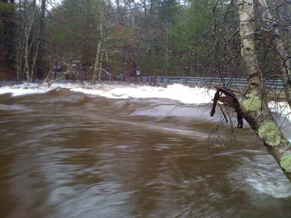
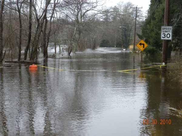
The Pawcatuck River has suffered extensive flooding, and flood related damages most extensively by super storm Sandy and the historic March 2010 Flood. Significant flood damage has occurred in both Connecticut and Rhode Island. Water management both from a quantity and quality perspective is an important consideration for the Pawcatuck River Watershed. The Army Corps of Engineers (ACOE) has performed a Reconnaissance Study to evaluate the nature of the flooding, the magnitude of the flood damage, and measures that may exist to mitigate this damage. A follow-up ACOE feasibility study was also funded through a grant from Hurricane Sandy relief funds. The RI Nature Conservancy also received a Hurricane Sandy Coastal Resiliency Grant to reduce Pawcatuck River flooding impacts and improve fish passage through the removal of the White Rock Dam in 2015. National Oceanographic Atmospheric Agency (NOAA), The US Fish & Wildlife Service (USFWS), and the Natural Resources Conservation Service (NRCS) have invested significant funds toward the removal of multiple dams on the Pawcatuck River and the restoration of fish passage at several other dams along the Pawcatuck River. In addition several studies relating to water supply and water quality have been funded by the State of Rhode Island. The federal and state governments have recognized the Pawcatuck River and its watershed as a highly valuable watershed worth preserving and protecting and thus have invested millions of dollars within this watershed. This planning effort has complemented and guided many watershed projects and continues to serve as a guiding document to protect and enhance your natural resources.
Hurricane Sandy Coastal Resiliency Grant Program
WPWA utilized the grant to develop a comprehensive flood and storm damage resiliency and watershed management plan with an emphasis on stormwater and flood management. The plan is not all about flooding, it speaks to best practices for land use and also promotes the benefit of protecting water quality and aquatic habitat. The project evaluated a variety of alternatives to determine which are most cost effective, including recommendations for mitigation measures. This can be accomplished in a variety of ways,each of which were evaluated and publicly vetted. The plan provides tools to the community that can help them develop greater resiliency to impacts of future storms and climate change including resistance to greater precipitation events resulting in larger flood events, more severe hurricanes and tropical storms resulting in greater occurrence of inland flooding, dam failure, stream and river erosion, and channel restricting sedimentation events. These tools were developed in such a way that community resiliency can be strengthened by enhancement of the watershed’s natural systems. The communities that can benefit from this planning effort include property owners, governments, and developers. The watershed planning document provides the following:
- Identification of known flooding/erosion/sedimentation problems in the watershed, building on the FEMA Flood Insurance Studies and the work that the Army Corps has already done for the larger urban flooding areas of Westerly and focusing on the stormwater management in the upper watershed. The Corps states in their reconnaissance report that stormwater management is a critical component in the success of flood management in the watershed.
- Identification of all dams in the watershed and a preliminary feasibility assessment of the potential for their removal or replacement to eliminate the risk of failure during future storms and the subsequent damages resulting.
- Identification of hydraulic structures in the watershed, including bridges and culverts, and an assessment of their flood conveyance capacity and the potential flooding or road damage that they cause if they are undersized. Identification of improvement alternatives including increased culvert sizes, to mitigate flooding and erosion damages. This evaluation would also include the assessment of aquatic connectivity. The culverts or bridges that are both undersized and restricting hydraulic connectivity are an intersection of two issues that can be addressed simultaneously with the same action and would provide a natural systems enhancement while strengthening community resiliency.
- Identification of opportunities for Green infrastructure in the upland to reduce stormwater runoff flows to mitigate current flood flows and to guide development in a manner that does not increase the current hydrologic response of the watershed in flow peaks, duration and volume of flood flows.
- Identification of areas where sediment removal could result in greater flood conveyance capacity and/or flood storage resulting in reduced flood elevations and/or peak flows.
- Fluvial geomorphological assessment of the stream and river systems in the watershed, to identify the classification of the watercourses and the likelihood that the stream channels will migrate over time due to natural channel processes, increased flow from the watershed, or man-made modifications to the hydraulic system. Over time, streams meander laterally, and fill or degrade vertically as they adjust to their water levels, sediments, and slope. Stream channels may change suddenly and catastrophically. The area of active stream channel movement is called the Fluvial Erosion Hazard Zone. Identification of the Fluvial Hazard Zones in the watershed would provide valuable information to land owners and the Town to allow for planning of more resilient land use in the future.
The watershed management plan enables towns and landowners to plan wisely for land use initiatives in the watershed including development and redevelopment activities. It was written for implementation by both the public and the private sectors in selecting lands that are free of specific hazards or that are valuable to be developed in a specific way that would minimize hazard potential and enhance resiliency. Similarly some land may be so sensitive as to be deemed good candidates for preservation by the community and a plan for acquisition can be developed with the property owner. This plan is a useful tool for use by municipalities as zoning, regional growth nodes, open space preservation, and at Statewide Planning for land-use management initiatives.
The success of this watershed management planning effort was dependent upon the development of a plan that reflects the consensus of the watershed Towns and landowners. This was accomplished through a well-facilitated process where information was shared throughout the development of the plan and interested parties were given ample opportunities to be informed, to ask questions and to contribute to the process. The objective at the completion of the management plan development was to have a plan that reflects the consensus of the Towns and whose recommendations are logical and clearly outlined as to how they can be implemented. WPWA has a track record of working cooperatively and respectfully with land owners and the communities within the watershed.
Steering Committee Materials:
Kickoff Meeting Notes March 26, 2015
Kickoff Meeting Presentation Slides March 26, 2015
Wood-Pawcatuck Steering Committee Meeting May 21 2015
Proposed Technical Assessment Methods and Geographic Priorities
Resources:
Pawcatuck Flood Resiliency Watershed Plan Slide Presentation by Erik Mas of Fuss and ONeil
Coastal Fellows Poster: Fluvial geomorphic and flood hazard assessment for the Wood-Pawcatuck Watershed created by Nate Lukas and Zack Valerio